Friday, December 30, 2011

Trekking the Miura Alps


I feel there is a lot lost in translation between English and Japanese (and I add my fair share translating it back into English), which is why trekking the Miura Alps is not quite as awe inspiring as it sounds.

Alps are, in Japan, any mountain range, and this streaches the definition of 'mountain' to near breaking point. The Miura Alps are the mountain range that run down the center of Miura peninsula, with a culminating peak is at just over 200m (that is 2 hundred, yes).


Having searched rather in vain on internet for new walking paths in the hills behind Oppama and Kanazawa-hakei, I was pleased to happen upon a map of a new hiking trail in Zushi! _Turns out I should have been searching for trekking courses, not hiking courses!_

My enthousiasm quickly waned when I discovered, using my 'real' map (a street map made by a company, and therefore showing nearly all the roads and paths of Zushi city), that this path was mainly on paved roads, except for a small excursion into what appeared to be a sports complex.
Determined to try out the path anyway (one never knows!), I found a few little detours on the 'real' map, that I thought might be interesting.


So early this morning, I set off my lunch, map and camera for Zushi. By train. From the Keikyu station, I then wandered down a part of Zushi I had never been in before, with an odd assortment of very very old, beautiful wooden houses, and very modern 'architect' houses.

The first of my detours I never found, as where it was shown to start on my map turned out to be a cemetary, and I had no intention of wandering among the graves looking for my path.

So back to my 'hiking course', which was, at this point, the main road going through a long tunnel between Zushi and Hayama. In the tunnel, I passed a group of people all holding the same printed out map of the Zushi hiking course. Now I walk faster than most japanese, but like to stop and take photos and such, so for the next 10 minutes we kept overtaking each other.


Then, my second detour loomed large in front of me. This path also started next to a shrine, but it was clearly marked, and so up up I went. As my confidence in reading, or at least deciphering kenji increases, so does the size of my hiking paths decrease.


But the paths are always well marked, and it gave me plenty of excuses for a breather to have to stop and get out my map to match up the kanji on the sign with the kanji on my map. This is not always possible, as my 'real' map is a road map, and so doesn not necessarily mark the name of every hill, especially if they are not accessible by car.

A forest fire extinction tank and bucket.

By this method I made my way easily up to the top of my 'detour' mountain, and found that, as hoped, there was another way down. My 'real' map showed a dead end, but so far during my rambles in Japan, I have never encountered a well-marked dead end. They will attach a rope to a tree and have you rapel down a cliff face rather than have you go back the way you came.


This new route continued on to 二子山, top and bottom. 二子山 bottom being the smaller of the 2 mountains, the taller one being the culminating point of the Miura Alps, at 207.8m. From there, a wonderful view of Tokyo Bay, again all the way to Tokyo. I shall have to add that new Sky Tree to my list of landmarks, in with Oppama's red Yokosan, and the big Sumitomo things.


Then down to a small stream, and following the stream to its source gradually got closer to Taura. More beautiful forests,


more wonderful views of Tokyo Bay,


even a glimpse of Fuji-san, right behind 二子山, and the path opens up to the uppermost part of the Taura plum grove.

Fuji-san, between the tower and the twigs _ white with snow.

Despite being much less lost these days, Taura plum grove is still no where near any station, and so it was still another 30 minutes' walk to finally get to the station. Taura being in Yokosuka city, I kept walking off the edge of my map, but finally recognized a road I had taken on my first bicycle outing. As I had also been lost last time, it wasn't much help, but I eventually wandered back into the map zone, and finally caught a train home.


Miura peninsula is only 10km wide, and the highest peak is hardly more than a hill, but if you take the detours, you can walk for 5 hours without seeing a paved road, and your muscles will tell you that 150m-tall hills are quite a climb, if you go up (and down!) enough of them!

Thursday, December 22, 2011

Autumn leaves


The calendar says it's Christmas time, and the narcissus have just started blooming, but for the tree world, it is now autumn! And I had every intention of enjoying the beautiful autumn colours Japan is so famous for!

The view from the steps to the house


Today I set out on a well-planned walk into the hills behind Oppama, wich quickly turned into my favorite "got lost, got back onto a known road, got lost again and finally ran into a train station and came home" kind of walk.


I started out on the Buddha hiking trail to Jinmuji, with only a couple sightings of fat grey squirrels. The Buddha is still doing well, but now has a fuzzy hat of pampas grass.


The view from the lookout tower was, as always, beautiful. It was overcast, so Fuji-san was not visible, but on Tokyo Bay side, the couds has parted, allowing an amazingly clear view all the way to Tokyo. The new completed Sky Tree was very obvious, despite it being blue, and that's more than 50km away!


I followed the main path for quite some time,


before being inexorably pulled aside by several smaller, but well-kept paths heading off into the forest! These turned out to lead around the hills and valleys paralelling the main path, before joining it again.


It was on one of these side paths that I found a small little rock outcrop, bathed in sunlight, and overlooking the forest (and a bit of freeway and high tension lines _ this is rather a unavoidable problem in this area), and decided to stop for lunch. Halfway through my sandwich, the shadow of a kite came over me, and sure enough, he had his eyes on my sandwich!
Now after the rather unfortunate event of having the last of a -cheese!!- sandwich plucked from my hands by one of those horrible birds, I don't like them much. But it is the Christmas season, and one must try to be forgiving! And besides, I had had a wicked idea!
Being on an outcrop, if I could throw a bit of my bread far enough into the air, would the kite not swoop down right close to me to get it? And would that not be a terriby thrilling experience?
The next 15 minutes were the most fun I've had in a long time, throwing bits of bread in the air and having the kites swoop down, catch them, and then gobble them up from between their toes as they gained altitude again. I also attracted a large crow, who took to scuttling around the scrub brush below the outcrop, eating up all the missed bits.

When more and more kites kept coming, I decided to stop, as it's fun with only 2 but with 15 it looks and feels a bit like a Hitchcock remake.
So off I went down the path, and ended up on the hiking course that leads either back to Oppama, or to Taura station.


Now I knew from experience that the path to Taura station is closed at that end. Yet there was no sign on this end, and no sooner had I started down the path that a runner passed me. At the speed he was going, he would either pass me coming back before I was even half wath through if it was a dead end, so off I set off to find where this end of the path went to. Turns out it does go to Taura, but joins the main road quite a way from the station.


One mystery solved, many more yet to investigate, as I saw many a small branching path on today's rambling that will need investigating! I wonder if japanese officials consider "there are lots of little paths behind Oppama that I haven't been on" a valid reason for wanting an extended visa?

Saturday, December 3, 2011

Kimono


For the end of term, my japanese school propose various events, to allow foreigners to experience japanese life, or at least parts of life they don't get to experience every day. This year, they proposed a 'lets wear a kimono' event, which I was most enthousiastic to join!
Not only is wearing a kimono not your everyday japanese life, it is something few Japanese have a chance to do, apart from at their wedding day.

The class was at a scmall school near Tokyo station, very chic and refined, but the 2 teachers we had were absolutely marvelous, and spoke very slowly and clearly, so we could follow without any trouble. 'We' was a Korean lady and myself, so it was pretty much a private lesson!


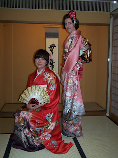
We got to put on the most formal type of kimono, the furisode, with long, ankle-length sleaves (or at least, close to the ankles of a shorter person). As is common in Japan, it is the kimono with the fewest yet most elaborate designs that wins in status over the complicated flower or bird motifs. The plain top and middrift of the fancy kimono then allowing for a more elaborate obi.

The putting on of the kimono is a lot like being tied up like a parcel. There are undergarments, and towels, and rags, and strings, and sashes, and little rolls to give volume, and little cards to stiffen thens up, and pins, and elastics, ... But eventually, all the trailing bits are neatly tucked out of sight, and after a few last tweaks,


Voilà!


After a long photoshoot, we then learned the basics of how to accept tea and sweets, which led to a lot of 'am I doind this right' sidways glances, and a lot of 'you had better do that again from the start', but was very fun.


All in all, it was an amazingly rewarding experience. The teachers were superb, the kimono was really quite fun to wear, once you get it on. It is a pity the price, and time and skill it takes to put it on someone means it is slowly going into disusage.

Kagoshima


Kagoshima is a small city at the southern most tip of Kyushu, and that is where our latest Tansei-maru cruise let off.


Its most remarquable point is the very large, very impressive, and very active volcano Sakurajima. This volcano squats in the middle of Kagoshima Bay, and, by satellite view, turns out to be 'nothing more' than the plug in the middle of a rather larger caldeira, now filled with water and called Kagoshima Bay.


Although still active, there is no sign of any erruption of that magnitude again, so we all set off in a jolly little pink boat to walk around the shores of Sakurajima.


It is really quite impressive to walk along the beaches there, as there is absolutely nothing besides lava, pumice and ashes. Wonderful wikipedia tells me that I called lava is actually tephra, which, in non-geologist talk, are basically 'bits of rock that flew out of volcanos but have now landed'.


What trees and grasses there are, are of the sturdy dune type, living in nooks and crannies in the rocks., although the lower slopes of the volcano support nice sub-tropical forests and citrus plantations.


The temple on Sakurajima

The city of Kagoshima itself mostly lives of fishing and farming, both of which produce amazingly good foodstuffs! However, due to the near constant activity of Sakurajima, the city is absolutely covered in volcanic ash. There is ash in the streets, making dunes along the curbes, there is ash that somehow manages to creep inside and coat everything in a thin grey shawl; and it regularily rains ashes like snow. The people are quite used to it, even having special 'ash bags' that you put out with the garbage in the morning, but I'm not sure I would really like to live there!